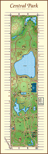
All the map images in this section are adapted from the Central Park Map Print. The map you see here is a small picture of this fine-art quality print. This distinctive map print is unique in that it shows the topography of the Park as well as over 57 miles of pathways, all the Park streets, 14 lakes and ponds, over 48 buildings and structures, the bridle paths, 12 adjacent museums and landmarks, and the names and locations of 31 sculptures and fountains. It even shows where the landscape is forested and where it is more open.
Larger View | Ordering Info
Using the map to explore Central Park
From here you can go to a larger view of the complete print which has links to even closer views of the section of the Park you may be interested in.
OR
Pick out the section that you're interested in on the map on the left then just click on it for a larger view. You might want to do this to avoid downloading the whole map as above.
OR
Use the Central Park Locator which lists the names of all the sites, areas, buildings, sculptures and sites adjacent to the park that are mentioned on the map. Clicking the button next to what you want to locate takes you directly to a close-up view of that area of the park.
